IEDs With Range
A thought experiment about America’s own unresolved backyard disputes, and lessons from the Iran war on the changing tyranny of distance.

I spent a weekend thought exercise thinking about the unthinkable, and what would escalated conflict in North America look like.
The 2000s had a signature weapon: the improvised explosive device. Cheap, ugly, lethal, hard to attribute, and strategically out of proportion to its cost. The 2010s were the decade of anti-access and area denial, of long-range missiles like the DF-21 and DF-26, and of navies relearning what distance meant. For the first third of this decade I expected the 2020s to be characterized by hypersonics.
That was wrong. The wars in Ukraine and around Iran have been defined by something cheaper and less elegant: one-way attack UAVs. A Shahed-class drone is, functionally, an IED with range. It takes the core tactical fact of the roadside bomb and adds hundreds or thousands of kilometers.
That changes the way old disputes look.
For my entire life, the geography of North America has been one of America’s defense assets. Oceans on two sides. Canada and Mexico on the other two. Friendly neighbors, integrated economies, long institutional habits, and an interior that distance keeps safe.
But distance only protects you when range is expensive. And both the Iran and Ukraine wars showed how a non-great power can match their will against a great power; without nuclear weapons.
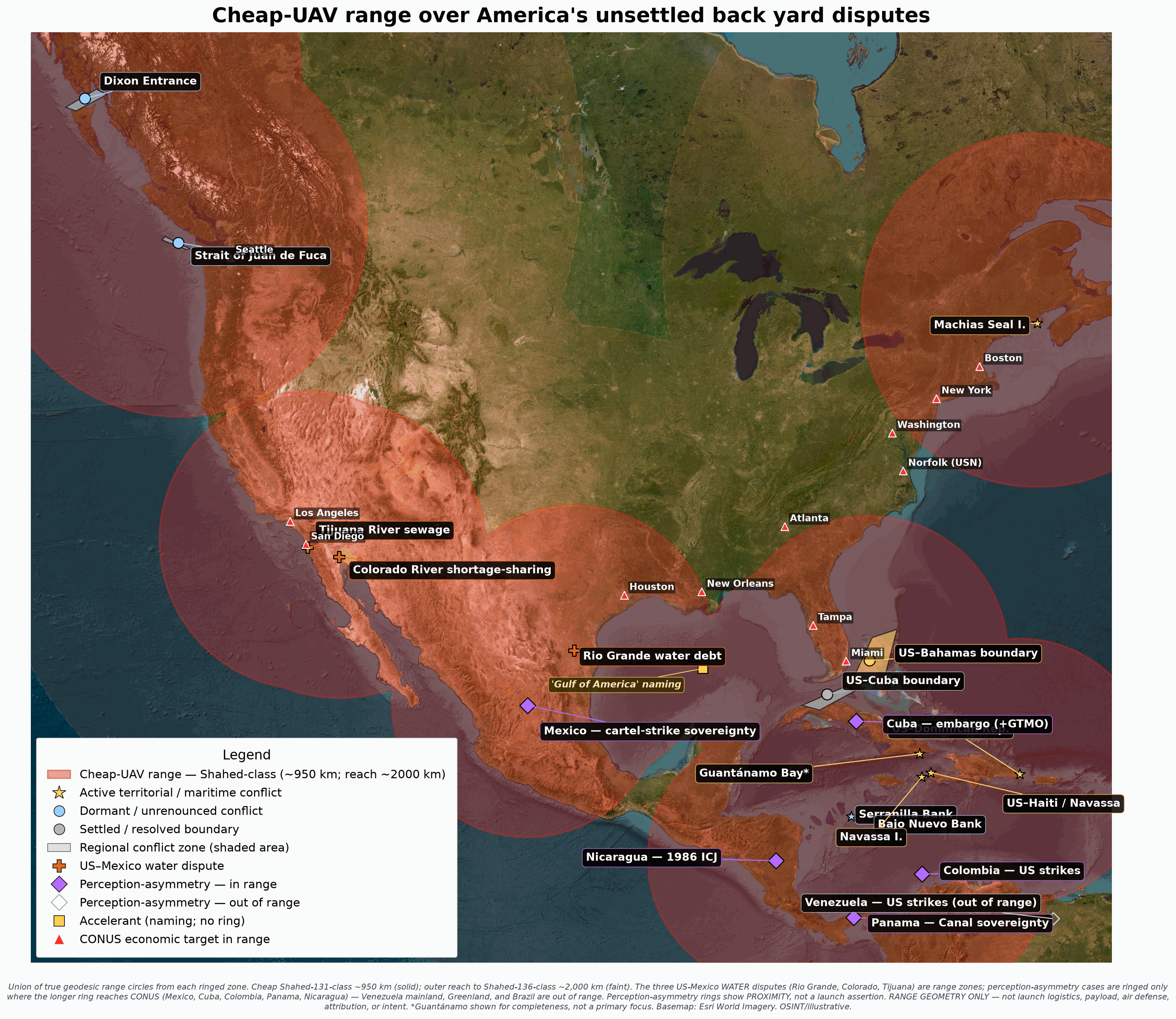
So I built the map I needed to see but didn’t really want to see. Where are the unsettled US territorial, maritime, EEZ, water, and border-adjacent disputes? Which are real conflicts, which are symbolic flashpoints, which are old paper claims, and which parts of CONUS fall inside the geometry of cheap one-way UAVs if those regional disputes ever stopped being managed over a pitcher of McNallys ale?
Again, this is intended as a “what if” thought exercise. I would prefer our regional disputes keep being negotiated over a pitchers of beer.
Bottom line up front
I cataloged 39 American backyard disputes: 16 active, 3 dormant, 2 latent, 8 largely resolved, and 10 resolved; and another 8 perception-asymmetry cases, where another country counts or experiences a conflict with the United States that Washington does not track as a territorial, border, or sovereignty dispute.
The strangest case is Serranilla Bank, a western Caribbean reef where Colombia keeps a naval garrison on a cay tied to a US claim that Washington never formally renounced and no longer presses. That makes Serranilla a potential flash point. It is an example of the category: a dormant legal fact, a physical outpost, a resource squeeze, and a deteriorated diplomatic relationship all stacked in one place.
The Mexico cases need a different vocabulary. The Rio Grande water debt, the Colorado River shortage-sharing fight, and the Tijuana sewage crisis are real conflicts. They are not classic territorial disputes, but they are real interstate stressors with legal instruments, deadlines, money, public health, and retaliation tools attached. The new Mexico cartel-strike case is different again: a sovereignty conflict Mexico sees in threatened unilateral US force, while Washington frames it as counter-narcotics.
This is a thought exercise in the unthinkable: regional armed conflict in North America and the Caribbean. It is worth doing precisely because the premise has been unthinkable.
There are more potential flash points within UAV range of the United States than I expected, certainly more than I wanted, and enough that maybe it isn’t unthinkable.
Conflict is up, but mostly not by shooting

The first result is not a border result. It is a temperature result.
2025 was a structural break in new US disputes. Count by counterparty and you get roughly 43 new disputes. Count by episode, where one tariff wave is one event rather than twenty-six country rows, and you get roughly 4.
Severity weighting does not make it disappear. In the severity-weighted series, 2025 is roughly 4.5 times the next-highest year. But the stack matters. This is not primarily a shooting-war spike. It is trade, sanctions, diplomatic coercion, and pressure tools. The militarized slice grew, but it did not define the tower.
That is the right frame for the rest of the article.
The geopolitical temperature is up. Most of the heat is economic and diplomatic. The risk is not that a tariff order becomes a drone strike. The risk is that an environment where economic coercion becomes normal is also an environment where old boundary disputes are less insulated from national politics.
Some disputes have nowhere physical to go. A name change does not move the Gulf. Others have a cay, a reef, a fishery, a river, a base, a strait, or a continental shelf. Those are the ones where political heat can become the flashpoint. So let’s map those.
Chasing waterfalls
First, we built a registry of the disputes. Not just islands. Maritime boundaries, EEZ overlaps, river-boundary residues, water treaty conflicts, sewage infrastructure, and symbolic sovereignty fights. Then we separated the old “is this a dispute?” question from a more useful one: what is the current US posture on paper? Then we pushed on the blind spot that mattered most: what if the US does not count the conflict at all?
Those two axes do not always line up.
A case can be active in daily politics even though the underlying line is settled by treaty. The Colorado River is a real conflict even though the legal entitlement is not vague. A case can be dormant in public and still unrenounced on paper. Serranilla and Bajo Nuevo are like that. A case can be loud and symbolic but not a real territorial conflict at all. Gulf of America is like that. And a case can be experienced abroad as a sovereignty conflict while Washington files it under national security, sanctions, counter-narcotics, trade, or old litigation.
Then we pulled filings from the other side too to help identify potential blind spots. Where the dispute had a physical surface, we looked at imagery. A cay, a lighthouse, a garrison, a sewage outfall, a reservoir bathtub ring, a runway, a reef. Where a 2025 or 2026 fact was load-bearing, we separated official acts from rhetoric.
The loudest sentence is often not the most important fact. Sometimes the most important fact is the thing a government did not say.
Then we drew the UAV envelopes from these disputed areas.
What cheap UAV range adds
A Shahed-131-class envelope is not a CONUS-wide blanket if you only ring islands and maritime edges. From the Gulf of Maine and Machias Seal Island, it touches New England. From the Juan de Fuca and Dixon Entrance region, it touches the Pacific Northwest. From Caribbean dispute zones, the cheap envelope reaches parts of Florida and the Gulf edge, while the longer Shahed-136-class envelope reaches much more of the Gulf Coast and Atlantic seaboard.
The water disputes changed my concern and the geometry because they sit on the border itself. Thirsty people can blow up dams. Once Rio Grande, Colorado, and Tijuana are included as stress zones, the cheap ring covers much more of the populated lower 48, and the longer Shahed-136-class ring puts every flagged CONUS economic target inside the footprint.
That is important. It keeps the piece from becoming fantasy, but it also keeps the border in view. Cheap drones do not erase distance everywhere. They erode it at the margins, and the margins are exactly where maritime, territorial, water, and sovereignty disputes live.
The map includes the Rio Grande, Colorado River, and Tijuana sewage conflicts because they are real. They involve treaty obligations, deadlines, crop losses, public-health closures, project delivery, and pressure tools. They can raise temperature. They can sour a relationship. They could produce retaliation.
The perception-asymmetry rings work the same way. Mexico, Cuba, Colombia, Panama, and Nicaragua are ringed because their 2,000 km geometry reaches CONUS. Venezuela’s mainland, Greenland, and Brazil are not. The rings show proximity to the US homeland. They do not assert capability, staging, sponsorship, or intent.
So the map asks two different questions:
Where is range cheap enough to matter?
Where is political temperature high enough that range might someday matter?
The inventory: most of this works

Before getting to the strange cases, it is worth saying the reassuring part clearly.
Most of the diplomacy machinery works.
Boundary commissions work. IBWC minutes work. Treaty settlements work. Arbitration worked in the San Juan Islands. The US gave up dozens of old Pacific guano claims by treaty. The US and Mexico settled the Chamizal. The Western Gulf gap is delimited. Many Caribbean lines are applied even where Senate ratification lags.
The live residue is smaller than the complete catalogue.
But the residue has a pattern. It clusters at the edges: Arctic shelves, lobster waters, open straits, tiny islands, reefs, banks, old guano claims, and water systems under climate stress. Some are active and managed. Some are dormant and unrenounced. Some are symbolic. Some are real conflicts that are not territorial in the classic sense.
The most dangerous analytical mistake would be to flatten them. Machias is not the Colorado River. Serranilla is not Gulf of America. Tijuana sewage is not a maritime boundary. Bering is not Wake. The categories matter because the escalation pathways differ.
The conflicts only one side is counting
There is a class of conflicts where the other side counts a dispute with the United States and the United States does not. That does not mean the other side is correct on the law. It means the political fact exists abroad while the US bureaucracy files the same episode somewhere else.
Panama is the cleanest territorial example. A US threat to “take back the Canal” did not become a US territorial filing. Washington treats the issue as China leverage and strategic messaging. Panama treated it as a sovereignty threat serious enough to raise at the United Nations under the Charter’s prohibition on force. The Canal is not an old paper claim like Serranilla. It is the reverse: the US is the actor, Panama is the state logging the conflict, and the US does not call it a dispute.
Greenland is the other territorial example. Denmark and Greenland hear acquisition talk as a sovereignty threat. Washington calls it strategic interest. Again, there is no formal US claim to map. The point is not that a Danish island suddenly becomes a conventional border dispute. The point is that one side hears coercion while the other side refuses the category.
The counter-narcotics cases are sharper because they involve force. Venezuela frames the 2025-2026 Caribbean campaign as aggression and regime change. Colombia frames the strike campaign as a sovereignty violation, separate from Serranilla. Mexico responded to cartel-strike threats by hardening its anti-intervention posture. The US language is different in all three: counter-narcotics, counter-terrorism, sanctions, interdiction.
Then there are the economic and legal cases. Cuba treats the embargo as aggression and bundles Guantanamo into the same narrative. Nicaragua still treats the unpaid 1986 ICJ judgment as live. Brazil frames sanctions and tariffs tied to its domestic judiciary as sovereignty interference. Those are not border disputes. They are not launch geography. But they are part of the same pattern: the US acts, the other government counts a conflict, and Washington does not count a dispute.
That matters because Serranilla is not just weird on its own. It is one direction of a larger asymmetry. At Serranilla, the US holds a dormant claim and does not press it while Colombia occupies the rock. In the newer cases, the US is the actor and the other country is the one saying, in effect: you are in a conflict with us whether you admit it or not.
The common thread is silence. Not absence of action. Silence about category.
Serranilla Bank: the weirdest case

Serranilla Bank is the case that makes the whole project feel less like a catalogue and more like a warning label.
On Beacon Cay, Colombia maintains a compact naval outpost: roughly fifteen marines, a lighthouse, barracks, solar power, cisterns, tracks, and a cleared pad whose function should be described cautiously. It may be aviation-related. It may be a utility or turning pad. The imagery does not prove a helipad (there is no windsock or big H).
The cay is small. The legal problem is not.
The United States claimed Serranilla and Bajo Nuevo in the nineteenth century under the Guano Islands Act. In 1972, the US and Colombia signed the Vasquez-Saccio Treaty to clean up a set of Caribbean cay claims. The US renounced Quita Sueno, Roncador, and Serrana by name. It did not name Serranilla or Bajo Nuevo. Article 7 preserved matters the treaty did not address.
That means the US claim was never formally extinguished.
It also means the easy conspiracy version is wrong. A dedicated archival dig found no evidence that Washington deliberately kept Serranilla and Bajo Nuevo as strategic leverage. The record leans against it. Across 1890, 1928, and 1972, neither side appears to have put the two banks at the center of the bilateral negotiation. The safer line is the truer one: shelved by inattention, not preserved as a weapon.
The modern US posture is even stranger. The US has not formally renounced the claim. But it has stopped acting like an owner. Its December 2023 extended-continental-shelf package named no Caribbean region. NOAA charts no US maritime line at the banks. Current maritime databases attribute the waters to Colombia, while still flagging the US claim at Navassa. The silence is not a footnote. The silence is the fact.
Colombians have called this litigio silencioso, silent litigation.
One side occupies the cay. The other retains a paper title it does not use.

The resource squeeze is not hypothetical. It is fish.
After the 2012 International Court of Justice ruling shifted rich fishing grounds toward Nicaragua, the Raizal fishing community of San Andres lost access to waters that were not abstract legal space to them. They were livelihood, food security, and identity. The lobster collapse is not a metaphor. It is measurable.
The oil story is different. There is unproven hydrocarbon potential in the broader region. There is no public reserve estimate for the disputed zone. The one frontier well came up dry.

The diplomacy is a potential accelerant. The US-Colombia relationship ruptured in 2025: decertification on 15 September 2025, an OFAC designation of President Gustavo Petro personally on 24 October 2025, and a lethal Caribbean and eastern Pacific boat-strike campaign that became Operation Southern Spear. Colombia’s strike grievance is its own perception-asymmetry case, distinct from Serranilla. A February 2026 Oval Office meeting improved tone but it did not reverse the instruments.
Tone is not policy.
There is no evidence Washington intends to revive the Serranilla claim. I assume no one in the US Government remembers there is a claim but it’s easy to find for anyone looking. The risk is that in a resource or diplomatic rupture, an unrenounced paper claim gives an administration a legal vocabulary to light a fire.
That is how dormant claims become dangerous. Not because they predict war. Because they remain available.

Two guardrails keep the story credible.
First, the 2012 ICJ case did not extinguish the US claim. The US was not a party. It also did not “enclave” Serranilla and Bajo Nuevo the way careless summaries sometimes imply.
Second, Colombia is not “arming an island against the United States.” Colombia is garrisoning territory it administers as its own, backed by a World Court judgment as against Nicaragua. The drama is a latent clash of titles, not an active US-Colombia military standoff.

The contrast with Bajo Nuevo is useful because it reduces the story to one sentence: Colombia mans one and lights the other.
Canada: allied management and Arctic reopening
The Canada disputes are the best evidence that old conflicts do not automatically become military problems.
The Beaufort Sea wedge is active. The United States published extended continental shelf limits in December 2023. The US and Canada created a Beaufort boundary task force in September 2024. US Arctic offshore-leasing planning advanced through 2025 and into 2026. There is real resource value there, and climate change is making the shelf more legible as a commercial and strategic space.
But there is still cooperation.
The Northwest Passage is even clearer. The US rejects Canada’s internal-waters position and treats the Passage as an international strait on paper. But it has never run a freedom-of-navigation operation against Canada there. Canada is absent from recent US operational-assertions reports. Washington challenges Russia and China with ships. It challenges Canada with law, notes, restraint, and probably a few drinking contests.
That is what the system working looks like.
Machias Seal Island is the human-scale exception: a lighthouse, puffins, lobster, and two flags. The temptation is to overheat it because a president restated the US claim in June 2025. But the operational incident people remember was in 2018 where US Border Patrol vessels stopped Canadian fishing vessels, and there was a collision between a US Coast Guard vessel and a Canadian lobster boat. The 2025 statement was messaging. The distinction matters.
The sentiment shift in Canada is not just about any single boundary. It is about sovereignty talk. Northern and Indigenous voices have hardened around “nothing about us without us,” while broader Canadian opinion sharpened after a year of annexation and “51st state” rhetoric. That does not make a boundary fight likely. It makes boundary management something no longer doable at the bar.
Mexico: three real water conflicts, one sovereignty case, and one symbolic flashpoint
The Mexico section needs careful sorting.
There are three real water or public-health conflicts.
Rio Grande water debt is a real conflict. Mexico owes water under the 1944 treaty. Cycle 36 closed in deficit in late 2025, with Mexico having delivered roughly half the required amount. The US denied a Tijuana water request on 20 March 2025. Trump threatened a 5 percent tariff on Mexican goods on 9 December 2025, but the tariff was not actually levied. A deal followed on 12 December 2025, and a technical plan was announced in February 2026. The pressure worked tactically. The structural fight remains.
Colorado River shortage-sharing is a real conflict. Here the obligation runs the other way. The US owes Mexico a treaty floor, and the shortage-sharing architecture around Minute 323 (meeting minutes from the International Boundary and Water Commission of the United States and Mexico 323rd meeting) expires on 31 December 2026. A successor is not yet signed. 2026 is a Tier 1 shortage year. This is not going to end well.
Tijuana sewage is a real conflict. It is not a sovereignty dispute, but it is a cross-border public-health crisis. Imperial Beach closures, polluted surf zones, sickened military trainees, and a binational infrastructure chain running through Minute 328, a July 2025 EPA-SEMARNAT memorandum, and Minute 333 in December 2025. This is not symbolism. It is waste in the water.
Then there is a sovereignty case.
The cartel-strike conflict is real, but it is not a water dispute. The US designated cartels as foreign terrorist organizations in February 2025 and floated unilateral strike options. Mexico heard that as a threat to act on Mexican soil, water, sea, or airspace without consent. President Claudia Sheinbaum’s government moved to harden Article 40 of the Mexican constitution with anti-intervention language. Washington frames the same pressure as counter-narcotics. Mexico frames it as sovereignty. Cartels are known to respond with force and they are probably better resourced than some western hemisphere countries.
Caribbean: old claims and modern stress
The Caribbean is where the legal ghosts live.
Navassa is the precedent. The US administers it as a wildlife refuge. Haiti claims it. The US reactivated a dormant Guano Act claim there in 1916 and never left. That is why Navassa matters to Serranilla’s Columbian garrison. It proves the mechanism exists.
But Navassa also shows why analogies can mislead. At Navassa, the US holds possession. At Serranilla, Colombia does. At Serranilla, Colombia also has the 2012 ICJ judgment against Nicaragua behind it. A US move there would be weaker and more provocative than Navassa was.
Guantanamo is a live lease standoff. It belongs in the conflicts catalogue and on the appendix map. The base is politically radioactive, the lease history is its own universe, and there already are far better writeups of GTMO than I could do.
The newer Caribbean stress is not an island claim. It is the strike campaign. Venezuela frames US operations as aggression. Colombia frames at least one strike as murder and a violation of its waters. Cuba frames the embargo as ongoing aggression and connects that story to Guantanamo. Washington does not track these as disputes. It tracks them as counter-narcotics, sanctions, terrorism, and policy.
The Bahamas, Dominican Republic, and Haiti maritime cases are quieter. They are EEZ geometry, not mass-politics. But they matter to the map because they sit close to Florida, Puerto Rico, and the Windward Passage. The quiet lines are often the ones that only become visible when something valuable is discovered or when enforcement changes.
The Caribbean lesson is simple: the strangest claims are not always the loudest ones.
Pacific and Bering: farther out, still real
The Pacific cases are not central to CONUS cheap-UAV range, but they matter strategically.
Wake Island is the most open US Pacific sovereignty dispute. The US administers it and has invested heavily in military infrastructure. The Marshall Islands claim it as Anen Kio. That claim is not the fake micronation story. It is a serious cultural and historical claim on the record.
The Bering Sea line is another one to watch. The US ratified the 1990 Baker-Shevardnadze maritime boundary in 1991. Russia never ratified it. Both sides have applied it provisionally, but Russia formally objected to the US Arctic continental shelf filing on 18 March 2024. A provisional line between nuclear powers in a warming Arctic is not an academic footnote.
The Mariana ECS overlap with Japan is the opposite case: a real seabed overlap handled by allies as a technical issue and probably settleable with a karaoke competition. Swains/Olohega is state-to-state settled but still alive as a Tokelauan cultural grievance. The Pacific is mostly the good-news control group: treaties work when both sides choose closure.
What the map does not say
The entire piece depends on restraint. A map is not a prediction. Range is not capability. Capability is not intent.
Rhetoric is not policy unless it becomes an official act: a filing, sanction, tariff, treaty minute, operational move, published boundary, lease program, or administrative change.
For most of American history, geography did part of homeland defense for free. Two oceans and two friendly borders put the interior beyond the reach of most regional conflict. Cheap UAVs do not erase that advantage. They soften it at the margins.
The margins are where these disputes live.
Appendix: The Conflict Zones Behind The Map
This is the field guide to the conflict zones: what they are, why they matter, what the imagery shows, what sentiment has changed, and what would make the risk move.
How to read this appendix
The main article uses a simple distinction.
Conflict zones are places where a territorial, maritime, EEZ, island, strait, or base dispute has geography. They can appear on a map. They can anchor a range ring.
Conflict flashpoints are stressors that can raise the political temperature without being launch geography. The three US-Mexico water and public-health conflicts are real conflicts. Gulf of America is not. It is a symbolic naming flashpoint.
Perception-asymmetry conflicts are cases where another government counts or experiences a conflict with the United States that Washington does not track as a territorial, border, or sovereignty dispute. Some are territorial in another country’s eyes. Some are military, legal, or economic. They are grouped separately because the escalation pathway is different.
That is why this appendix groups the cases by escalation pathway rather than by database row.
1. The northern maritime edge: Canada and the Arctic
Beaufort Sea
The Beaufort Sea is a friendly dispute with serious material stakes.
Canada’s position follows the 141st meridian north from the land boundary. The US position uses an equidistance line that bends eastward. The wedge between them is roughly Lake Ontario-sized and sits over an oil and gas province. The broader Arctic shelf context got much sharper after the US published its extended continental shelf limits in December 2023.
This is not a hostile file. The US and Canada created a joint task force in September 2024 to negotiate the boundary. The important fact is that the file is active again. Climate, seabed value, and continental shelf law turned an old managed line into a current negotiation.
Sentiment is not anti-American in the ordinary sense. Northern anger often aims at Ottawa. The recurring line is that Arctic decisions cannot be made over the heads of Inuvialuit, Inuit, territorial governments, and northern communities. The politics harden when sovereignty becomes a southern slogan and northern people are treated as scenery.
Risk moves if the task force stalls while leasing or shelf assertions advance. The current file is cooperative. The danger is a gap between negotiation tempo and resource tempo.
Central Arctic and Beaufort extended shelf
The Central Arctic extended-shelf overlap is the quieter, deeper version of the Beaufort problem.
In December 2023, the United States published outer limits for its extended continental shelf. Canada already had an Arctic submission in the Law of the Sea process. Where those asserted seabed entitlements overlap beyond 200 nautical miles, the issue is not a coastline visible from shore. It is a deep seabed claim, tied to oil, gas, minerals, mapping, and the long future of Arctic access.
This is not a popular flashpoint yet. There is little local public voice around the exact deep-shelf geometry. The better local frame is Inuit Nunangat: Arctic sovereignty cannot be treated as an empty federal chessboard. The people who live with the consequences do not want to be treated as scenery.
Risk moves if the Beaufort task force stalls, if leasing or seabed claims advance faster than diplomacy, or if Russia and China pressure the Arctic enough that Washington and Ottawa stop treating the overlap as a technical file.
Northwest Passage

The Northwest Passage is a legal-status dispute, not an areal boundary fight.
Canada treats the Passage as internal waters enclosed by Arctic straight baselines. The US treats it as an international strait. That sounds confrontational until you look at the instruments. The US has protested diplomatically and maintained its position on paper. It has not run a freedom-of-navigation operation against Canada (yet?).
That contrast matters. The US uses operational assertions against rivals. It has not done that to Canada. The mechanism is legal disagreement plus alliance management.
Sentiment changed less because of the Passage itself than because of broader sovereignty rhetoric. Inuit and northern leaders increasingly frame Arctic security as housing, food, infrastructure, search and rescue, and self-determination. After a year of annexation-style rhetoric from US politicians, the Canadian public mood hardened around sovereignty. That makes quiet management politically harder even if policy does not change.
Risk moves if a US or allied ship transits without Canadian consent and turns a paper disagreement into an operational one. That has not happened.
Machias Seal Island and the Gulf of Maine Grey Zone

Machias Seal Island is tiny, photogenic, and unusually concrete. The US and Canada both claim the same dry land. Around it sits the Gulf of Maine Grey Zone, where lobster makes the abstract line economically real.
This is not a new crisis. The dramatic boarding event often cited in the press is from June 2018, not 2025 or 2026. The 2025 development was rhetorical: a US presidential restatement of the claim. That distinction is essential. Rhetoric can raise temperature, but it is not the same as a new enforcement action.
Sentiment is divided in a way that makes the case interesting. National and provincial politicians can be sharp. Local fishers often live with the ambiguity because they have to. The Grey Zone is a worksite before it is a symbol.
Risk moves through enforcement, not speeches: arrests, gear conflict, patrol refusals, or USMCA-linked pressure around fishery regulation.
Dixon Entrance and Juan de Fuca
Dixon Entrance and the seaward Strait of Juan de Fuca are quieter than Machias and Beaufort. They matter because they show how long a line can remain unsettled without becoming central politics.
Dixon is a Canada-US disagreement over the A-B line and maritime delimitation. It flares around fisheries. Juan de Fuca is smaller and more technical, frozen partly because boundary method precedents matter.
These are dormant or low-salience disputes with real geography. Their risk is not ideology. It is a fisheries or enforcement incident that forces a government to defend a line it usually prefers to ignore.
2. The US-Mexico water and infrastructure flashpoints
The Mexico section has to be kept clean.
There are three real water or public-health conflicts: Rio Grande water debt, Colorado River shortage-sharing, and Tijuana sewage. They are not territorial launch zones, but they are real interstate disputes with legal instruments and material harm.
Gulf of America is not a real territorial conflict. It is a symbolic naming flashpoint.
The separate Mexico cartel-strike sovereignty case is handled in the perception-asymmetry section below. It is a real sovereignty conflict, but it is not a water dispute and not a naming fight.

Rio Grande water debt
The Rio Grande conflict is the sharpest US-Mexico water file because Mexico owes the United States.
Under the 1944 treaty, Mexico is supposed to deliver an average of 350,000 acre-feet per year from named tributaries over five-year cycles. The cycle ending in late 2025 closed with Mexico far short, roughly half of the required amount delivered. The US denied a Tijuana water request on 20 March 2025. The administration threatened a 5 percent tariff on Mexican goods on 9 December 2025, but it was not actually levied. A deal followed on 12 December, and a technical plan was announced in February 2026.
That sequence matters because it shows escalation. A water dispute became a trade threat, then a delivery plan. The tariff did not happen, but the threat had negotiating value.
Sentiment is already hot. In northern Mexico, water politics have produced protests, barricades, and violence. The 2020 La Boquilla confrontation, where Yessica Silva was killed, sits behind the modern grievance. On the Texas side, the conflict is framed in agricultural survival terms: sugar, citrus, irrigation districts, and jobs.
Risk moves if the next cycle inherits the deficit without predictable deliveries, or if the “extraordinary drought” clause becomes a permanent excuse rather than an emergency exception.
Colorado River shortage-sharing

The Colorado is the mirror image of the Rio Grande.
Here the US owes Mexico. The 1944 treaty gives Mexico a baseline entitlement, modified in practice by shortage-sharing minutes. Minute 323 expires on 31 December 2026. A successor is not yet signed. 2026 is a Tier 1 shortage year, and the broader post-2026 Colorado operating rules are still unsettled.
The conflict is real because the deadline is real. It is a treaty architecture reaching the end of its current operating framework while the reservoirs remain stressed.
Sentiment on the Mexican side is local and existential. Mexicali Valley farmers and Cucapa voices talk about a river that no longer reaches the sea, about dying fields, and about an ecological system turned into an accounting problem.
Risk moves if the successor minute is not signed in time, if basin-state politics freeze the US position, or if shortage reductions become harder to sell to Mexican users who already feel they are carrying another country’s drought.
Tijuana River sewage

The Tijuana River sewage crisis is a real conflict because the damage crosses the border every day.
Untreated flows have closed beaches, sickened people, and made South San Diego’s coastline a public-health zone. This is not a line on a map. It is human waste in the water. The governing chain is technical but important: Minute 328 in 2022, the EPA-SEMARNAT memorandum in July 2025, and Minute 333 in December 2025. The question is whether the infrastructure build-out meets its schedule.
Sentiment is local, angry, and practical. Imperial Beach wants the beach open and the smell gone. Tijuana needs wastewater capacity. National governments announce milestones; border communities live with the outflow.
Risk moves if project deadlines slip, funding breaks, or the promised wastewater capacity fails before the next major storm season.
Gulf of America
Gulf of America is not a real border conflict.
Executive Order 14172 changed US federal usage. Federal agencies updated names. Some maps and platforms displayed different labels by user location. Mexico objected and litigated. Politicians performed sovereignty.
No maritime boundary moved. No EEZ moved. No lease block moved. No fishery moved. No continental shelf entitlement moved.
That is why it belongs in the article as a flashpoint but not as a conflict. It measures political temperature, not territorial reality. If the article treats it as equivalent to Rio Grande, Colorado, or Tijuana, it is wrong.
Risk moves only if symbolic nationalism spills into real instruments: trade retaliation, energy permitting, maritime enforcement, or treaty cooperation. The name itself does not change the map.
3. Other Mexico and Gulf technical flashpoints
These cases are not the heart of the article, but they close important gaps in the map.
Transboundary hydrocarbons
The US-Mexico transboundary hydrocarbons agreement is a settled-boundary, unsettled-implementation case.
The 2014 framework exists so reservoirs that cross the maritime boundary can be developed by unitization rather than by a race to drain the same pocket from opposite sides. That is the good-news part. The flashpoint is not a line. It is whether political energy nationalism, Pemex finances, and US-operated Gulf projects can make the framework work when a shared reservoir matters.
Risk moves if a commercially meaningful cross-border reservoir is found and the two sides disagree over operatorship, revenue, data sharing, or unitization terms. The boundary is settled. The resource politics are not guaranteed to be boring.
Eastern and Western Gulf gaps
The Western Gap is mostly closure. The in-force 2001 treaty split the deepwater doughnut hole in the Perdido Fold Belt, with the United States getting the smaller share and Mexico the larger share. It belongs in the appendix because it is proof that a large offshore resource boundary can be settled cleanly.
The Eastern Gap is cleaner on paper than in institutional process. The United States, Mexico, and Cuba have treaty architecture that largely settles the deepwater eastern Gulf, but US Senate consent and the three-party Cuba tripoint remain the loose ends. That does not make it a hot dispute. It makes it a technical file that could become politically relevant if offshore activity or US-Cuba relations change.
Risk moves if Senate consent remains stalled while leasing, seabed activity, or Cuba policy changes create a reason to care about a line most voters have never heard of.
Rio Grande bancos and shifting river islands
The Rio Grande bancos are the older, quieter version of the border-water story.
Rivers move. Boundaries do not always move with them. The United States and Mexico built a treaty system to handle bancos, islands, channel changes, and rectification, including the 1905 and 1970 rules. Hundreds of small pieces of land have changed sovereignty under that machinery.
The case is largely resolved, but not dead. Border barriers, levees, flood-control work, and channel maintenance can still create accusations that one side is prejudging an island, impeding flow, or violating the free-flow and maintenance logic of the boundary regime.
Risk moves through engineering, not ideology: a wall segment, levee project, flood event, or IBWC disagreement that forces governments to answer which side of a moving river a piece of land belongs on.
The 1978 and 1997 US-Mexico maritime boundary
The US-Mexico Pacific and Gulf maritime boundary is backbone context.
The 1978 treaty and later entry into force give the two countries the basic territorial sea and EEZ framework within 200 nautical miles. That is why Gulf of America does not change anything, and why the real modern Gulf questions are the deeper shelf gaps, hydrocarbons implementation, and resource administration rather than the basic maritime line.
This is not a flashpoint, and it keeps other flashpoints from being worse.
4. The conflicts only one side is counting
The project started by asking where the United States has unsettled territorial, maritime, EEZ, water, and border-adjacent disputes. That question naturally privileges what the US government says or does not say. We also asked the inverse question: where does the other side think it is in a conflict with the United States even though Washington does not track the case as a dispute?
That distinction matters because Serranilla is only one direction of asymmetry. At Serranilla, the US holds a dormant claim it does not press while Colombia occupies the cay. In the new cases, the direction often flips. The US is the actor, the other government experiences a sovereignty problem, and Washington calls the same episode national security, counter-narcotics, sanctions policy, trade policy, or closed litigation.
Panama Canal
Panama is the cleanest territorial example because the legal geography is not obscure.
The Canal is Panamanian. The modern sovereignty settlement is the 1977 Torrijos-Carter treaty architecture. A US threat to “take back the Canal” therefore does not create a normal boundary dispute. It creates a perception-asymmetry case. Washington can frame the issue as messaging, China leverage, or strategic concern. Panama can treat it as a sovereignty threat.
The official act is Panama’s response. Panama filed a United Nations complaint invoking Article 2(4) of the UN Charter after the US threat. That does not mean the US filed a claim. It did not. That is the point. The US does not need to log a dispute for Panama to experience one.
The Canal case should not be written as a settled boundary suddenly becoming unsettled. It should be written as a sovereignty system reacting to coercive language. The risk pathway is diplomatic and economic first: port concessions, audits, treaty language, pressure on Chinese-linked infrastructure, and the possibility that rhetoric gets translated into administrative or military planning.
Greenland and Denmark
Greenland is the other territorial case, but it is stranger because geography pulls it into North America while sovereignty remains Danish and Greenlandic.
The US does not have a formal claim to Greenland. It has strategic interest, acquisition talk, and messaging that would not rule out force. Denmark and Greenland hear that differently. Danish intelligence treated the United States as a national-security threat for the first time that we could find, and Denmark summoned the US ambassador over Greenland-related concerns.
This is not a drone-range case for CONUS. It is out of range on the article map. It belongs because it shows the same category problem. Washington can say there is no dispute. Denmark can still treat US pressure as a sovereignty problem.
Venezuela
Venezuela is the marquee military-sovereignty case.
The United States frames the 2025-2026 Caribbean campaign through counter-narcotics and counter-terrorism. Venezuela frames it as aggression, regime change, and violation of sovereignty. That difference is not just rhetoric layered on nothing. The underlying US acts are official: strikes, designations, operations, and force.
The article map does not ring Venezuela’s mainland because the CONUS geometry does not reach cleanly from the mainland case under the working assumptions. But the case is still central to the appendix because it shows the category gap at its highest intensity. One side says interdiction. The other side says war.
That does not make Venezuelan claims true in every legal detail. It means the article should not let US category language erase the fact that the other side is counting a conflict.
Colombia strikes
Colombia now appears in the article twice, and the two appearances must not be collapsed.
Serranilla is a dormant paper-claim problem. The US claim is unrenounced but silent, and Colombia physically administers the cay. The 2025 strike grievance is different. It is a live sovereignty and force problem created by US counter-narcotics operations, decertification, sanctions, diplomatic rupture, and Colombian allegations that Colombians were killed and Colombian waters were violated.
That makes Colombia the bridge case. It is both the home of the article’s weirdest dormant territorial claim and one of the new perception-asymmetry cases. The same bilateral relationship carries both forms of stress, but they should not be treated as one dispute.
The writing line should be: Serranilla is the dormant legal vocabulary; the strike campaign is the active diplomatic accelerant.
Mexico cartel-strike sovereignty
Mexico has three real water or public-health conflicts in this article. The cartel-strike issue is not one of them. I almost treated the cartels as nation-state for the purposes of this thought exercise.
The US designated cartels as foreign terrorist organizations and floated unilateral strike options. Mexico responded by hardening anti-intervention language around Article 40 of its constitution. The substance is not a boundary line. It is whether the United States may use force on Mexican territory, water, sea, or airspace without Mexican consent.
That makes it more serious than Gulf of America and different from Rio Grande, Colorado, and Tijuana. It is not symbolic naming. It is not water accounting. It is the old non-intervention principle meeting a new US counter-narcotics theory.
The map rings Mexico because the geography is obvious: it is the US border. That ring is not a claim that Mexico would launch anything. It is a reminder that an unfriendly border changes the defense geometry immediately. And the cartels are a well resourced military-capable actor in and of themselves.
Cuba embargo
Cuba is partly already in the catalogue through Guantanamo Bay. The embargo is different.
The US treats the embargo as sanctions policy. Cuba treats “el bloqueo” as economic aggression and often folds Guantanamo into the same anti-sovereignty narrative. The UN General Assembly vote is useful here not because it decides the legal question, but because it shows the persistence and scale of the foreign-perceived grievance.
Nicaragua 1986 ICJ judgment
Nicaragua is a legal-memory case.
In 1986, the International Court of Justice ruled against the United States in the Nicaragua case over mining harbors and support to the Contras. The US never paid the reparations Nicaragua says it is owed. Washington treats the matter as closed. Nicaragua periodically treats it as unresolved, including through later UN correspondence.
This is not a territorial dispute. The Bryan-Chamorro and Corn Islands residue belongs in the resolved-history bin. But the unpaid ICJ judgment is still useful in the article because it shows how legal time differs between capitals. A case the US treats as dead can remain politically alive for the other side.
Brazil sanctions and tariffs
Brazil is the weakest of the new live cases for this article.
The issue is not land, water, or maritime space. It is economic and judicial sovereignty: US sanctions and tariffs tied to Brazil’s domestic judicial politics and the Bolsonaro prosecution. Brazil frames that as interference. The US frames it as sanctions and trade policy.
Brazil is out of range on the CONUS map and should not be over-weighted. It belongs as a category marker, not as a central scene. Its value is that it shows the perception-asymmetry pattern can appear outside the Caribbean and outside classic territorial claims.
Negative controls
The negative controls are important because they keep the appendix from becoming a grievance collector.
Ecuador and Bolivia are reversed cases. Ecuador’s current government has courted US basing rather than treating it as a live government-level sovereignty conflict. Bolivia’s new government readmitted the DEA in February 2026, which retires the old anti-empire framing at the state level for now.
Guyana, Suriname, Peru, Paraguay, and Uruguay do not fit the pattern. The current government posture is partnership, not a foreign-perceived US conflict.
Argentina and Chile in Antarctica are latent only. Their claims run into the US non-recognition and reservation posture, but the Antarctic Treaty freezes the problem and their sharper friction is with the United Kingdom, not the United States.
Honduras and the Swan Islands are the resolved foil. The US had a Guano Act claim and gave it up by treaty in 1971-1972. That matters because it proves the US can let one go. It is the clean Navassa comparison, and a useful reminder that not every old guano claim has to stay weird forever.
5. The Caribbean: old claims, bases, and EEZ geometry
Serranilla and Bajo Nuevo
Serranilla is the centerpiece because it combines every ingredient the article is about; and quite honestly I found it really interesting.
There is a physical outpost. Colombia mans Beacon Cay. There is a dormant paper claim. The US never formally renounced Serranilla or Bajo Nuevo. There is resource stress. The Raizal fishery around San Andres has collapsed. There is diplomatic stress. US-Colombia relations deteriorated sharply in 2025. And there is silence. Washington has not reasserted the claim.
That silence is what makes the case unusual. Active claims are easy to see. Dormant claims are not. Serranilla is a title that remains available without being used.
We’ll be careful writing down the visual evidence. The garrison is compact and persistent. It is not a sprawling base. The 2018-2025 imagery shows entrenchment, not a build-out.
The resource story should also be disciplined. Fish is fact. Hydrocarbons are unproven. A seabed discovery could change the risk environment, but the current human conflict is about fisheries, livelihood, and the Raizal sense of sea-territory.
Bajo Nuevo is the contrast: same dormant US claim family, much less physical presence. Colombia lights it with a beacon. It does not man it like Serranilla.
Navassa

Navassa is the precedent.
The US administers Navassa as a wildlife refuge. Haiti claims it. The US reactivated a dormant Guano Act claim there in 1916 and still holds the island. That is why Navassa matters in a Serranilla article. It proves that dormant guano claims can be revived as state claims.
But the analogy has limits. At Navassa, the US holds possession. At Serranilla, Colombia does. Haiti also lacks the practical state capacity to press the claim the way Colombia can defend Serranilla. Navassa is the mechanism, not the prediction.
Sentiment is anti-colonial and diasporic. Haitian voices frame the island as stolen territory and resource loss. The state claim survives, but the state itself has bigger problems.
Risk moves if a stabilized Haitian government, diaspora legal campaign, or international forum makes Navassa a live diplomatic issue again.
Guantanamo Bay
Guantanamo is a real sovereignty and lease standoff, but it should not dominate this article.
The US treats the 1903 and 1934 instruments as preserving its right to occupy the base until mutual agreement or abandonment. Cuba calls the base illegal occupation and refuses to cash the rent checks. The base sits at a strategic point near the Windward Passage and carries all the political weight of detention, migration, and US-Cuba history.
It belongs in the appendix because it is a live territorial standoff in the region. It belongs outside the center because it would swallow the article.
Risk moves through base mission changes, US-Cuba diplomatic rupture, or a new use that makes the lease issue politically unavoidable.
Bahamas, Dominican Republic, Haiti, and Cuba maritime lines

The Caribbean also has quiet EEZ files that look dull until you draw range or find resources.
The US-Bahamas boundary is undelimited in several segments and became more salient after the 2023 US extended shelf filing. The Dominican Republic archipelagic-baseline dispute affects the Mona Passage near Puerto Rico. The US-Haiti maritime boundary is tangled with Navassa. The US-Cuba line is functionally applied but historically provisional because the 1977 agreement has not entered into force.
These are not popular mass conflicts. Sentiment is often thin, elite, or technocratic. Their risk is not street politics. Their risk is that an enforcement action, seabed discovery, migrant-route pressure, or formal court move makes a quiet geometry problem visible.
6. Pacific and Bering: farther from CONUS, still strategically real
Bering Sea
The Bering Sea line is the most strategically serious “farther out” case.
The US and Soviet Union signed the Baker-Shevardnadze line in 1990. The US ratified it in 1991. Russia never did. Both sides have applied it provisionally, but the line remains a political target for Russian nationalist resentment. Russia’s 18 March 2024 objection to the US Arctic extended shelf filing made the broader shelf dispute current again.
This is beyond the CONUS cheap-UAV frame, but it is not beyond strategic relevance. It is a provisional line between nuclear powers in a warming ocean.
Risk moves if Russia formally denounces provisional application, if fisheries enforcement becomes confrontational, or if Arctic resource bargaining turns the line into leverage.
Wake Island

Wake is the most open US Pacific sovereignty dispute.
The US administers it and invests in airfield and missile-defense infrastructure. The Marshall Islands claim it as Anen Kio. That claim is serious and cultural. It should not be confused with the bogus “Kingdom of EnenKio” micronation story.
The risk is not cheap-UAV range to CONUS. The risk is that a heavily militarized atoll with a live cultural claim becomes part of a broader US-Pacific Island negotiation over defense, compacts, and sovereignty.
Mariana ECS and Swains/Olohega
The Mariana extended-shelf overlap with Japan is the cooperative version of a real issue. Both sides are allies. The overlap is technical. It requires bilateral handling, but it is not a confrontation.
Swains Island, or Olohega, is the cultural version of a settled state-to-state issue. The US holds Swains as part of American Samoa under the Treaty of Tokehega. Tokelauan voices still treat it as a stolen fourth atoll. The state claim is settled. The grievance is not.
These cases are useful because they show that settlement and sentiment are different things. A treaty can close a state claim without closing a people’s memory.
7. Resolved controls: what closure looks like

The resolved cases matter because they gave me more hope.
The San Juan Islands were settled by arbitration. Chamizal was settled by treaty and land transfer. Rio Rico and the Horcon Tract were resolved after the river moved. The Western Gulf gap was delimited. The US renounced many Pacific guano claims by treaty with Cook Islands, Kiribati, Tuvalu, and others. The US-UK Caribbean boundaries are settled. The US-Venezuela Aves line is settled between those two states.
The water controls matter too. The All-American Canal lining case shows how a US infrastructure project can solve one legal fight while leaving a transboundary-groundwater gap in political memory. The Colorado salinity crisis, resolved through Minute 242 in 1973, shows the opposite lesson: a water-quality conflict that damaged Mexican agriculture could be converted into a technical binational settlement.
The small Pacific controls are boring in the best way. The Federated States of Micronesia, Niue, Cook Islands, Kiribati, and Tuvalu boundaries show what closure looks like when guano-era residue and EEZ lines are cleaned up by treaty. Not every old claim becomes Serranilla.
The system can work. The US does renounce useless claims. Boundaries do get drawn. Old disputes can become boring.